Espacios Naturales Naturaleza

EROSIONES DE BOLNUEVO
In the Pliocene era (5.3 million years) an event that would determine the evolution of the morphology of the Mediterranean coast took place: the formation…
In the Pliocene era (5.3 million years) an event that would determine the evolution of the morphology of the Mediterranean coast took place: the formation of the Strait of Gibraltar, which allowed the Mediterranean Sea to stop being a salty lagoon of small dimensions. In just two years, this opening to the Atlantic Ocean allowed the entry of waters that raised sea levels and occupied spaces until then separated from the sea, a phenomenon known as "marine transgression" - affecting the place where the Gredas de Bolnuevo are located.
As these spaces were covered by the sea, the marine currents dragged and deposited various materials (loams, silts, sandstones and gravels) that were sedimented and compacted creating a marine platform, which corresponds to the yellowish materials visible today.
Description
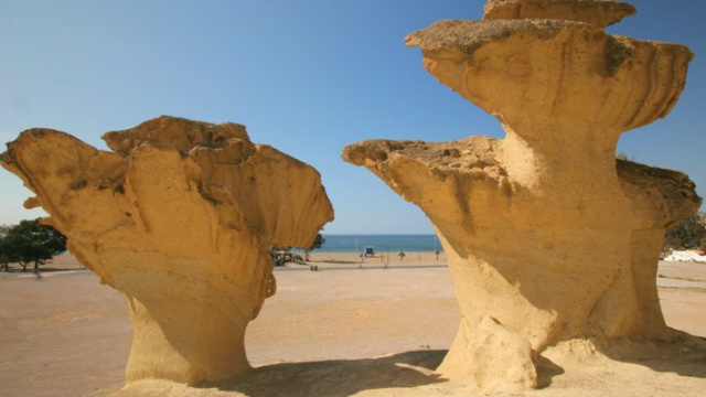
Las Gredas de Bolnuevo is a relief undergoing continuous transformation. Its profile has suffered wear due to the erosive action of wind and water, but this has not been uniform because its materials have different levels of resistance.
This relief is composed of an alternation of fine materials, such as sandy loams, also known as yellow clay, and sandstones, as well as thicker ones such as conglomerates. The sandstone sediments present abundant fossils of marine fauna, while in the clay layers, there are millions of microfossils.
The action of tectonics and differential erosion has shaped this unique landscape in which the following processes and geographical accidents are identified:
- Discordance between the different strata. Those layers of marine origin, composed of sandy loams, sandstones and silts from the Cenozoic, are distinguished from the layer of continental materials formed by reddish conglomerates from the Quaternary.
- Landslide. Tectonics has caused the rocks to slide down the slope.
- Paleochannel. Vestiges of an old canal whose waters carried reddish sediments from the Sierra de las Moreras.
- Faults. In the set, several “normal” type fractures or faults are distinguished, when presenting a vertical displacement of the strata.
- Deflation processes by wind erosion. The action of the wind causes the detachment of the particles from the loam and silt layers, as they are less compacted.
- Wind erosion abrasion processes. Gusts of wind with sand particles deteriorate the softer areas located from the base at a height of approximately 45 centimeters, causing the marked narrowing of the lower part of the relief.
- Ledges and escarpments. The selective action of the wind, the different degrees of strata foundation and carbonate precipitation processes, have led to the emergence of layers which are harder than the rest, forming a "cap" on the shapes and resulting in appearance of ridges or ledges.
- Honeycomb alveolar erosion. The action of the wind and the water drags the weakest parts of the sandstones, favoring relatively regular and contiguous cavities that resemble the structure of a honeycomb.

CALBLANQUE, MONTE DE LAS CENIZAS Y PEÑA DEL ÁGUILA
The Calblanque Regional Park is located at the eastern end of our coastline, between Cabo de Palos and Portmán. This enclave is characterised by the great…

SIERRA DE LA PILA
The Sierra de la Pila Regional Park is located in the north-east of the Region of Murcia in the municipalities of Abarán, Blanca, Fortuna and Molina de…

ARENALES Y SALINAS DE SAN PEDRO
The Salinas y Arenales in San Pedro del Pinatar Regional Park is a wetland located between the Mar Menor and the Mediterranean Sea, which has 856 hectares…

CARRASCOY Y EL VALLE
Download Brochure Regional Park El Valle y Carrascoy

CABO COPE Y PUNTAS DE CALNEGRE
Download Brochure Regional Park calnegre y Cabo Cope

CUATRO CALAS
The Cuatro Calas Protected Landscape is located next to the provincial border with Almería. It is a small coastal strip of 222 hectares, in which small…

ESPACIOS ABIERTOS E ISLAS DEL MAR MENOR
Download Brochure Islands and Spaces in The Mar Menor Vive el Mar Menor

BARRANCOS DE GEBAS
Do you want to know what the landscape of the moon looks like without leaving the Earth? Come to the Barrancos de Gebas (gorges), in the centre of the…

CAÑÓN DE ALMADENES
Download Brochure Protecte Area Cañon de los Almadenes

SIERRA DE LA MUELA, CABO TIÑOSO Y ROLDÁN
On the central stretch of the coast, a large stone mass rises above the waters of the Mediterranean. The materials we can find there are mainly limestone in…

ISLAS E ISLOTES DEL LITORAL MEDITERRÁNEO

SALADARES DEL GUADALENTÍN

CABEZO GORDO
El Cabezo Gordo originated in the Triassic, a division of the geological time scale, approximately 250 million years ago. At this time, the Earth underwent…

HUMEDAL DE AJAUQUE Y RAMBLA SALADA
Download Brochure Protected Landscape Ajuaque y Rambla

PARAJE DEL SALTO DEL USERO

EROSIONES DE BOLNUEVO
In the Pliocene era (5.3 million years) an event that would determine the evolution of the morphology of the Mediterranean coast took place: the formation…

MONTE ARABÍ
An elevated stone formation boasting a very beautiful and unique landscape. The erosive phenomena in its rocky walls are striking, having carved out…